

The Speed of Lummi Island
/Driving speed around Lummi Island is a best expressed as a cultural spectrum, irrespective of legal speed limits. The range of speed varies from completely stationary (when chatting up pedestrians) to “extreme ferry hyperdrive”.

Pedestrians brave the 35 mph zone on Legoe Bay.
Ferry hyperdrive is calculated as: rate equals the distance to the ferry landing divided by the panic of tardiness, where the ability to reschedule the mainland appointment is less than risk of public shaming on Nextdoor, squared by the number of concrete trucks in line for the ferry. Maximum ferry hyperdrive has only been achieved by practiced locals, clocking speeds that surpass the dread “tourist from the mainland otherworld”.
Thankfully our slower drivers (or “Slowers”) mitigate the speeders. The key to slowing on the island is to gingerly activate the accelerator pedal, with only the small toe if possible. The allows the slower’s expectant remaining toes to lurch over to the brake pedal upon any stimulus. Restraining faster drivers following behind is not enough for these rarified road heroes. To retard oncoming traffic, the Slower will straddle the centerline and bravely cross into the oncoming lane through blind corners. When encountering pedestrians it is a civic duty to run interference by veering the far edge of the opposite lane. Approaching traffic must then screech to a satisfying halt, known as the “Lummi Island traffic jam”. In California this is an invitation to mortal combat. Here, the participants will likely know each other and spark a spontaneous street conference.
The 25 mph myth
For a long time, the only regulatory signs on the island were “Speed Limit 25”. This may be the root of the incorrect but pervasive belief that all of Lummi Island roads are limited to 25 miles per hour. Or maybe that 25 mph is the maximum speed limit for incorporated city and town streets in Washington. RCW 46.61.400 (2)(a)
In fact, as an unincorporated area, all of the roads on Lummi Island are 35 miles per hour unless otherwise posted according to Whatcom County Code 10.04.050.
So where do maximum 25 mph zones actually begin and end? Why did Legoe Bay Road change from 25 to 35? And what happened to the Scenic Estates 20 mph zone?
Getting up to speed
There are only two stretches of road where the speed limit is 25 miles per hour, including a special mention of Loganita Lodge.
Nugent Road, between West Shore Drive and Legoe Bay Road. Coming off the ferry to Nugent Road this 25 zone extends south to intersection of Legoe Bay Road. Whether continuing south on Nugent or turning right on Legoe Bay Road the speed limit is then 35.
West Shore Drive, between Nugent Road and Blizard Road. If you turn right/north from the ferry on Nugent Road the 25 zone continues all the way north, swings around the Migley Point corner where the road changes to West Shore Drive. And it’s still 25 until the southern edge of the Isle Aire neighborhood where a vestigial of Blizard Road pops out. Southward and around Legoe Bay it is all a max of 35.
Speed limits for unincorporated county roads are listed in Whatcom County Code Chapter 10.04. The roads are listed alphabetically by speed limit, with Lummi Island roads somewhere in the mix.
County code includes this interesting artifact as a 25 mph speed limit. “LOGANITA LODGE and STEWART DRIVE. (Driveway into) For 600 feet north and 600 feet south of driveway into Loganita Lodge; Stewart Drive for its entire length; both of these roads being located on Lummi Island.” Loganita Lodge is long gone, now a private residence and farm. Stewart Drive is also a bygone mystery. If you find it, please do not drive faster than 25.
Legoe Bay goes from 25 to 35
One of the artifacts in the code is a mention of “County Road No. 122 in the vicinity of Legoe Bay”. Road #122 predates the namings of the road and includes all of Legoe Bay Road and continues north on West Shore Drive to Blizard Road. Way back when, this was all 25 mph and may explain why there was a 25 mph sign near Tuttle Lane until January, 2021. But in July 1982, An Ordinance to Establish Speed Limits on Lummi Island Roads set “35 mph on Legoe Bay Road, between West Shore Drive and Nugent Road”. This overrides the old mention of 25 mph on “Road No.122:. So the county finally replaced the 25 mph sign after almost 39 years of ingrained local assumptions.

Ordinance 82-43 of July 1982 set Legoe Bay Road at 35 mph.
But 35 was a little too fast along the bay, after all.
There are four sets of railroad tracks on this stretch of road used to launch reefnet boats. So the county’s solution was to add “Rough Road” warning signs and 25 mph advisory speed signs 200 feet in advance of the tracks in both directions.
Blizard, not Blizzard
Speaking of code artifacts... the road is Blizard, not “Blizzard” with two Zs. We have Paul Davis and the Tome to thank for this spell check, when in 1991 the Public Works department was alerted that this road was named for Lon and Sallie Blizard, not a snowstorm. While the street signs were corrected, the code still contains a bit of bluster.
The Scenic Estates fake
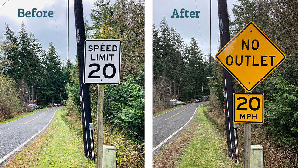
A spurious 20 mph sign replaced with an advisory sign where Seacrest Dr becomes Island Dr, at Cove Ave.
Sometime in the 1990s a 20 mph speed limit sign suddenly appeared at the entrance of the Scenic Estates neighborhood where Seacrest Drive becomes Island Drive. The county did not put it there. But when Public Works started receiving maintenance calls for this sign they diligently began repairing this cuckoo’s egg. In 1996 the sign post was replaced and the metal sign was replaced due to vandalism in 2000.
Legally is there is no 20 mph speed limit in Scenic Estates, no ordinance nor resolution, and no mention of a speed limit in the original 1959 plat. The speed limit in Scenic Estates has always been 35 mph.
Carved out of side of a mountain, Scenic Estates is a perplexity of blind corners, switchbacks, and narrow roads. So the county’s solution was to replace the fake speed limit sign with a 20 mph advisory speed sign and a “No Outlet” warning sign.
Select any of the highlighted sections to see details. Red is 25 mph maximum speed limit, blue is for school zone, and yellow is advisory speed.
What about advisory signs?
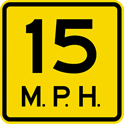
Advisory speed signs are yellow with black lettering. This is in contrast to regulatory white speed signs with black lettering. As “advisory” implies, this is a warning that conditions ahead may be unsafe and to slow down to the advisory speed. Advisory speed signs usually yellow diagonal sign above describing the condition, such as the “impaired sight distance” on Tuttle Lane (20 mph), or the sharp corner of S. Nugent Road and Sunrise (10 mph). But the regulatory maximum speed limit is still 35 mph at each of those locations.
The law relating to advisory signs is RCW 46.61.400. which states “The driver of every vehicle shall … drive at an appropriate reduced speed … when approaching and going around a curve, when approaching a hill crest, when traveling upon any narrow or winding roadway”. Advisory signs are simply giving drivers a heads up for these conditions.

“Elderly People Crossing” advisory sign in Scotland.
Safe for Conditions
Officers may ticket you at their discretion if your speed exceeds what they believe to be “safe for conditions”. That's true anywhere, but perhaps even more so if you're involved in a collision on a stretch of road marked with an advisory speed sign.
Our community would suffer societal breakdown if sheriff deputies ever came out to Lummi Island for traffic enforcement. There would be backchannel alerts to hide unregistered “island cars” and a prompt return to the house to retrieve one’s drivers licence and proof of insurance. This is why, pragmatically speaking, traffic speed enforcement is more effectively served by our semi-domesticated deer population.
Whatcom County doesn’t like speed bumps
Why aren't speed bumps put in place to slow down the traffic? The English call these “sleeping policeman” while cities such as Kirkland prefer a “speed hump” for it’s less aggressive nature. 😳
According the county’s website, “courts have held public agencies liable for personal injuries resulting from faulty designs. Increased hazard to the unwary; challenges to the daredevils; disruption of the movement of both emergency and service vehicles; and undesirable increase in noise” has led Whatcom County to not consider speed bumps as an option for traffic calming.
How to slow your roll
The Whatcom County Council has the authority to establish speed limits under RCW 46.61.415. Changing a regulatory speed limit is a both a political and practical consideration. A petition with overwhelming support of island population would be a good start. A homeowners association (especially with a vote of the membership) would also be influential. An engineering traffic study and review by the Sheriff’s Office may also be required.
In October 2020, Lummi Island Community Association (LICA) formed a Traffic Calming Committee, to investigate needs for better safety on our roadways. Further developments from the committee have been slow in coming. Maybe that’s the idea.
To contact LICA’s Traffic Calming Committee email tcc@lica.us.


